Tuesday, September 26, 2017

Bay of Fundy, New Brunswick

Although this trip is almost over (I'll get home sometime next week) there are still experiences that I'm mulling over and would like to share. 

After leaving PEI, my next stop was to see the tide change in the Bay of Fundy from the New Brunswick side; the best place for that was Fundy National Park. It's located near a tiny town called Alma, where you can see the tides on a different kind of shore.  This one has fewer cliffs and is more level.  That was apparent on the first day I was there.  In the morning, I took a photo from a boardwalk along the beach at high tide, then went exploring for the rest of the day. When I came back that evening, it was low tide, and I was astounded at how much beach was visible, compared to the morning. I would have had to walk almost half a mile to get to the edge of the water! It's hard to imagine the amount of water that rushes in and out of the Bay of Fundy twice a day!
 
High Tide at Alma


Low tide at the same place 

Explorations led me to several other points along the Bay: Cape Enrage, and Hopewell Rocks. I don't know where the name for Cape Enrage came from, but I loved the name. Although it was very foggy that morning, I found the location to be very intriguing.  I love the blurring of the lines of the shore and beach with the water and sky. Cape Enrage was most notable for the hundreds of cairns on the beach. Some of them were very complex shapes while others were simple piles of stones. When I came back to Cape Enrage at the end of the day, the tide was out, but it was still very foggy. I wonder if the fog ever completely disappears from that section of the bay!
 
Cairns at Cape Enrage, high tide

Cape Enrage, high tide

Cape Enrage low tide

Hopewell Rocks was almost an otherworldly experience. The huge pillars carved by the action of the tide over thousands (or millions) of years would have been hard to imagine. At low tide, they stand up like sentinels guarding the steep, rocky cliffs. They have trees growing on top, so that at high tide, they are more like islands off the shore.  I wasn't able to see them at high tide, but at low tide, they are most impressive.  To get to the ocean floor, you have to walk down a 101 step staircase (and back up it again when you are ready to leave). That may be part of the reason I chose not to come back at high tide! But I loved wandering around those huge pillars and thinking about how they were formed.

Hopewell Rocks
Hopewell Rocks


Hopewell Rocks


Hopewell Rocks -- Staircase
That night as I was cleaning up my dinner things, I started thinking about all the things I had seen, my list of Must See things, and wondering if there was anything I had missed. I remembered a spot on the drive to PEI where I crossed a river at a Tidal Bore viewing station. I was on the way to PEI and didn't stop to see what it was all about. But I wondered if I had missed something I would later regret.  My guide books were helpful in explaining the Tidal Bore, and I realized that I would definitely regret not seeing it once I got home.  So after checking the map and discovering that it was only 200 miles back to that place, I ditched my plans to move on, and moved backwards instead. I was there at 9:30 AM ready to see what this Tidal Bore Viewing Station was all about. Although the bore can be as much as 4 feet high, the sun, moon, and earth were aligned in such a way to produce a much smaller bore. It was still impressive. At the viewing station, the water in the river rose about 15 feet between 9:30 and 10:45 AM.  Can you imagine?  That's a huge influx of water in a short time!
 
Base of bridge pillar visible

45 minutes later

The interpreter at the Viewing Station said that it was also possible to see the bore at another place along the bay on the same day, so I headed to Truro to their viewing station. This happened about 11:30 AM. This one was like a small wave coming into the shore at the beach, but it didn't stop and retreat; it just kept coming and coming and coming. And as I sat there along the shore, the river rose about 5 feet or more in less than 10 minutes. Whoa! That is an impressive sight, even if it wasn't the 4 foot wave that sometimes happens.
 
Tidal Bore, Truro

Just a few minutes later


So now I leave the Bay of Fundy with no regrets, nothing unseen, and full of great memories of another bucket list item achieved.

Friday, September 22, 2017

Prince Edward Island

Prince Edward Island

It's called PEI by everyone I've talked to – Prince Edward Island is just too cumbersome to say, so from here on, PEI it is!  And what a place it is, too!  I spent yesterday driving around the Eastern part of the island, taking many small gravel roads that led to the beach (although I didn't know that when I took the first two or three), meandering along the roadway, sometimes stopping in the middle of the road to take photos (nobody was coming either way!).
 
Flowers in the ditches.

Birdhouse on a power pole!

Birds on the beach.

I am enchanted with this island.  It is peaceful, quiet, unhurried, and just really laid back, if I can use that phrase. As I was driving yesterday, I kept thinking how tidy it all was. The fields are neat, the homes are well kept, and the yards are mowed and nicely landscaped. The beaches are clean. The roads were sometimes not so great, but not as bad as some other places I've been on this trip (Newfoundland, I'm thinking of you!!). Even the roadsides are mowed!
 
Hay bales on a farm. 


The north shore, where I camped the first night (in wind so fierce I couldn't cook because the stove wouldn't stay lit) is the center for mussel farming, and I saw a number of those farms in St. Peter's Bay.  The lady at the visitor center was very informative when I went in to ask what all those buoys were in the water. The mussel farmers put very small mussels in what they call socks, which are long pieces of netting, and they hang them from the buoys. The mussels grow over the next 18-24 months, and when the farmer pulls up the sock, it is encrusted with mussels ready to eat!  I haven't had any yet, but I'm not finished with PEI yet either…

Today was devoted to Green Gables, of Lucy Maud Montgomery fame.  The house about which she wrote is now a national historic site, and the north shore where it lies is a national park. Since the morning was sunny and warm, I decided to drive along the shore road first (just in case it got nasty). It was breathtaking – the cliffs are red sandstone, and there were lots of pull offs so that I didn't run the risk of getting run over.  This part of the island had more people, tourists mainly, but still it was not very crowded.  I imagine that in the summer it might be quite different.


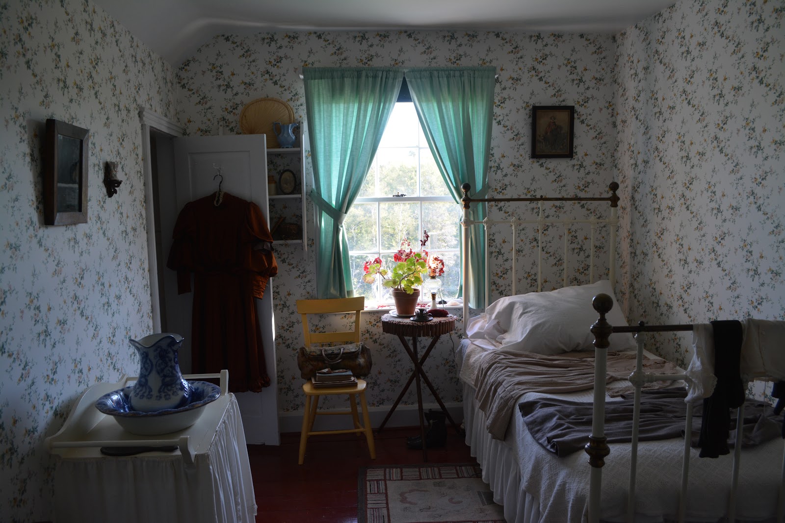
After the shore drive, I went to the house, which is open for tours and photographs are permitted.  Yippee!  I wanted to share the house with two of my daughters-in-law, both who love the Anne of Green Gables stories, so I can do that with pictures. It was fun to see how the house was furnished (with period pieces) and to imagine how it might have functioned back in the day.  The guidebook I'm using for this trip said that the whole thing was very much a tourist trap, but I found it very interesting and not as touristy as I expected.  Yes there was a gift shop, but it was away from the main part of the site, and it was easy to skip it if you wanted to (I didn't skip it!).
 
Green Gables

The dining room.

Anne's bedroom

Even some of the pathways that are described in the books were now made into walking trails, and I did one of them.
 
Lover's Lane trail. 

The sun stayed out, and it made for a very enjoyable day!

Tuesday, September 12, 2017

High Tide

The Bay of Fundy

View from my campsite at sunset. 


The whole inspiration for this trip was to see the tidal change in the Bay of Fundy.  I've been gone almost 2 months, and finally got to see it yesterday.  After an afternoon spent touring a couple of historic forts (Fort Anne and Port Royal) I followed the suggestion of a Visitor Information Center person and camped last night in Parker's Cove campground. I managed to get a site right where the grass becomes the rocky beach, and I'm sitting there right now watching the tide come in.  I decided to stay here an extra day so that I could watch the tide go from lowest to high. I'll be here all day taking pictures as it fills up the cove and comes almost up to my campsite. My heart is full!  Another bucket list item achieved!
Not quite low tide


High tide, the rocks have disappeared! 


Halifax and the South Shore

I'm not much for touring in cities – I prefer the national parks and other outdoor kinds of attractions. But Halifax seemed like a city I should at least take a look at, and I'm glad I did.  One of my best friends has a cousin who lives here.  She put us in contact, which made Halifax even more important.

The first day, though, I went into the city on my own.  First I did a city/harbor tour with a company that has amphibious vehicles that go from land to water and back. Kind of a fun concept, and it was a fun tour, which gave me an idea of where I wanted to go next and how to get there! The guide was a young college boy who knew his Halifax history, and shared some great stories while we were riding around. 
 
Harbor hopper
After lunch at a fish and chips stand along the waterfront, I decided that the main thing I had to see was the Citadel – the fort defending the city and harbor of Halifax. It was another beautiful day, and I spent the whole afternoon at the fort, talking to the interpreters, looking at the armaments, peeking into the various rooms, and admiring the view from the top of the fort.


Inside the Citadel

City View

The next day I met up with my friend's cousin, Frances, and after a stop at the memorial to the Swissair plane that crashed there, we went to Peggy's Cove – a fishing village south of Halifax, and apparently the #1 photographed town in Nova Scotia.  It was very pretty, the boats were lined up in the little harbor, the houses clung to the shores (some of them by the skin of their teeth!) and the lighthouse stood on the point.  What amazed me there was that the coast was smooth worn rocks – not small ones, or even medium size ones, but huge, bigger than house sized.  More like factory sized!  It was certainly a different kind of shore than I had seen before.
 
Frances!

Peggy's Cove

Peggy's Cove

Peggy's Cove Lighthouse

Rocky beach

After a lovely lunch (lobster roll!) we headed along the coast, stopping whenever I saw something pretty I wanted a photo of, and ended up in Lunenburg, a UNESCO heritage site. The town was built on a hill, and the streets were narrow, the houses an amazing array of bright colors, and there were all kinds of different fish sculptures hanging from the light posts.  Everywhere you turned your head there was something fun to look at.
 
Squid on the lamppost
Very colorful houses. 
The next day I was on my own and went back to Lunenburg to see the Marine museum there.  It also had some fish tanks, and a touch tank – one of my favorite things in a museum/aquarium. There was also a program going on about lobster fishing which proved to be quite interesting. They had preserved lobsters that were so huge I could hardly believe it – one that they said weighed about 40 pounds and was over 100 years old.

 
One HUGE lobster!

After a night in Yarmouth, and a shore drive up the Fundy coast in the fog (couldn't see a thing) I ended up in Digby for lunch.  A high school friend had told me that they have the best scallops in the world in Digby, and she was right! Thanks for that tip, Linda!
Scallops for lunch