Friday, July 26, 2013

Kate's Alaska (for my fellow Danamaniacs)


The main inspiration for this trip to Alaska was to see for myself where Kate Shugak lives, what she sees, and what life would be like there for someone besides Kate.  While I wasn't able to see everything I wanted to, and only got a fleeting taste of what life might be like, it was enough to satisfy my curiosity. Now when I read the books I can see in my mind what Kate (and Dana) are talking about.(For readers who don't know what I'm talking about, it's a series of books by Dana Stabenow.)

Some of the places I wanted to see I just wasn't able to – McCarthy (Niniltna) and the Kennecott mine, for example. But I did see the Independence Gold Mine site near Palmer, and I imagine that it was pretty similar. I didn't get all the way to the Nabesna mine, but I went out that road for about 18 miles, so I have a fairly good idea of what that might be like. I went through a lot of very small villages (Chitina for example) that must be similar to Niniltna.

And I discovered where some of the names in the book come from.  For example, Ahtna is not a town, but a Native Corporation with headquarters in Glenallen, right across the Richardson Highway from the visitor information center.  For a long time I didn't connect the Kanuyak River with the Copper River – bangs head on the desk here!!—and I imagined this river as wide and deep and clear. It's wide, not sure how deep it is, and when I was there it was very muddy. I'm still not sure how salmon survive in that water…..

The UA Fairbanks campus is quite beautiful, situated as it is up on a hill, with lovely stone buildings and pretty grounds. I didn't take a lot of pictures there, but certainly enjoyed my afternoon at the museum on campus. 

Anchorage was a little smaller than I had imagined, and the buildings weren't very tall. There were a few that were 10 stories or so, but most were much smaller – 2-3 stories. The parks were really pretty, though. I saw Earthquake Park (HUGE mosquito population!), Point Woronzof (gorgeous views), and Kincaid Park (wish I'd had a bicycle to ride the Coast Trail that goes through all three parks). One of the great things it had was a city-run campground.  It was very handy to be able to camp right in the city and not have to drive long distances to get "home" at night. The other great thing was meeting fellow Danamaniac Cathy Rose for coffee one afternoon.  What a treat that was!

Below are the pictures I culled that seemed to best represent Kate's Alaska. 
Wrangel-St. Elias Mountains from Canada

Same thing -- focused on the mountains rather than the foreground

Wrangell Mountains from Glenallen


Best picture of the Copper River

Bridge over Copper River, with Fish Wheel
 Copper River from overlook, looking North
Copper River from overlook, looking South


Chitina

Independence Mine

Did you ever wonder what Blazo was?  My picture of the Blazo Boxes got deleted :(
Beginning of the road to the Nabesna Mine
Along the road to the Nabesna Mine -- swans on the lake
Self explanatory!!
Trooper post at Tok (no helicopters though!)
Story Knife at Alaska Native Heritage Center Anchorage

Earthquake Park


Point Woronzof
Kincaid Park


Tuesday, July 23, 2013

Home Again, Some Final Thoughts


Not many people get to do what I had the opportunity to do over the last two months.  To be able to leave home for that long a period and to have no responsibilities to anyone (well, I did let a group of people know where I was each night thanks to my SPOT), and to be free to do as I pleased was a gift that I still can hardly believe.  I had wanted to go to Alaska, wanted to drive the Alcan highway, wanted to see bears and moose and caribou and birds and fish in the wild, for many years.  Now I've actually done it!

First some statistics if you are interested:
Time gone: 7 weeks, 5 days
Miles driven: 10,727
Mileage: 37 MPG (I still can hardly believe that one – thank you Toyota)
Pictures taken: about 2000
Car washes: 5 (and there should have been at least 2 more!)

There were some little things that I noticed along the way that just didn't make it into the blog, but I wanted to write about 
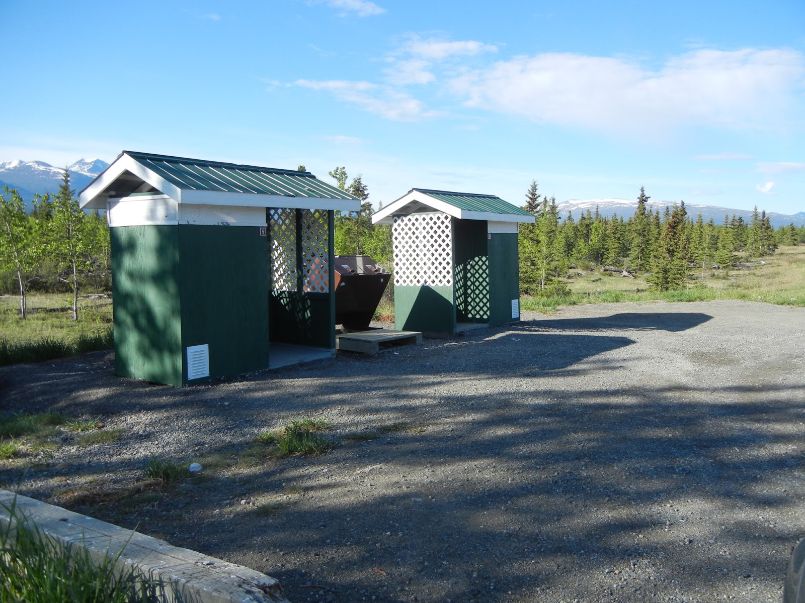
them. The first is the roadside rests along the Alcan Highway.  These are outhouses, but they have little porches on them with trellises on two sides. It makes them pretty, certainly, but after a long while I think I finally figured out why they were there. In the winter, the porches, and trellises, help direct drifting snow so that it doesn't pack up against the door, preventing access. But can you imagine trying to use that facility when there is snow up to here and it's 30o below zero?  I can't…but I'm not sure what else people who drive that highway in the winter would do.

Another is my assumption that things on the road would be similar to here in New Mexico. I couldn't have been more wrong. One of my weaknesses is fountain Diet Coke. I have one almost every day, and can't drink the canned or bottled stuff. Here it's easy to get one – McDonalds, and most every gas station, have drink fountains. I assumed I would find the same thing along the Alcan.  Ha!!  Gas stations were often a shack with two pumps outside.  Inside there was a wood stove, a chair, a small counter, and sometimes a cooler with cans and bottles of drinks. No "pay at the pump" card readers, no soft drink fountains. Some of the time I was just really glad there was gas. So when I found one, I was very grateful, and sometimes bought two drinks if it had been a while.

Gas was sometimes horribly expensive – about $7 per gallon.  I had one fill up where I needed just a little more than half a tank and it cost $72.  Ouch!!

Internet access was sometimes painfully slow. There were several occasions when it took almost an hour to upload 6-8 photos.  Those times had me pulling out my hair, but I kept reminding myself that I didn't have to be somewhere else, and I could spend the time.  It sure makes me grateful for what I have here at home. 

I've been asked what my favorite part of the trip was. That's a hard one to answer, but certainly Denali was a highlight. The other wonderful surprise was Valdez. I had not planned to go there, and did just on a whim.  I'm so glad I did. Not only did I meet some neat people, but I saw a place that was breathtakingly beautiful. 


Did I have any regrets?  Only one.  Last summer I toyed with the idea of getting a bicycle, riding it through the winter, and taking it with me. I decided that there probably wouldn't be much opportunity to use it, and didn't do it. I wish I had. There were lots of places I could have ridden it, and that would have been a lot of fun. There are bike trails in all the National Parks, and in so many of the other places I visited. So before my next trip, I'll be getting a bicycle, practicing on it, and it will go with me.  

So until the next trip (East Coast -- Maine and Nova Scotia), happy trails to all. 

                                                                    Sally

Saturday, July 20, 2013

Yellowstone On the Fly


Sometimes I get the most harebrained ideas that I can hardly believe it.  Like the one I had about driving quickly through Yellowstone Park to get home. OK, I had been there before, but that was 30 years ago (!) with three little kids that I was trying to keep entertained, and on the boardwalks instead of on the ground. Who has time to see much with all those distractions?  (Relax, boys, it was still a great trip, although with different priorities. You will understand in a few more years….)

I hadn't really stopped to figure out mileage, and speed limits, and those kinds of things, so kind figured I could get through the park by about noon (left Livingston MT at about 7 AM).  Those who don't preplan pay the price!  There was too much to see, and this park deserves a return trip (along with Glacier).

The first attraction was Mammoth Hot Springs. I didn't remember them being so active, with lots of steam coming out, and water pouring off the side of one mound.  Then there was a drive around the hot springs that I also didn't remember – that was fascinating, when you imagine how huge those hot springs must be. If only we could harness that energy and heat…

Mammoth Hot Springs

I'm always alert for wildlife, and although I didn't see much in Yellowstone, there was still an eagle, a buffalo, and an elk. 


I remembered Morning Glory Pool from that long-ago trip, and when I passed the road to the Fountain Paint Pots area and saw a blue pool, I thought that was it. The traffic to get into the parking lot was horrific – you can see the cars backed up trying to get into the parking lot – and there were nowhere near enough parking spots for all the people.  I had decided to go on and returned to the road through the park when I found another entrance to the lot.  And, believe it or not, I actually found a parking place!  Luck was with me.  This was not Morning Glory pool, it was Silex Spring, and the map I had didn't even list where Morning Glory Pool was.  I knew there had been earthquakes that caused changes in the park, and I thought perhaps Morning Glory pool was one of the casualties.  But I just now looked it up, and found where it is. Turns out that it has changed, but not so much due to earth forces as people forces – so much trash and other stuff has been thrown into the pool that it is no longer the glorious blue that it used to be. So I'll have to keep that one as a really great memory. Still Silex Spring was really pretty.

Silex Spring

The crowds on the boardwalk to the springs
After a stop for lunch and a slow drive through the rest of the park with stops for waterfalls and pretty "wet" pictures, I finally reached my highway at 3:30 PM and still had about 200 miles to go to my planned overnight stop in Rawlins Wyoming. 

Lewis Falls

Along the Lewis River
Almost to my turnoff -- this is the Tetons

That overnight was planned so that I would have an easy trip the next day (Thursday) to Fountain CO and my sister's house, then another pretty easy day home on Friday. That was better planning, because those two days worked out fine. I got home about 2 PM on Friday, July 19, after 7 weeks and 5 days.

I have some more things I'd like to blog about so there will be at least one more post before I end this blog, but be assured there will be other trips. This one was so great, and so successful, that I'm already planning the next one! 

Thursday, July 18, 2013

Glacier National Park


As I write this, I'm sitting at my sister's kitchen table, and dressed in something other than jeans!  It's the first time I've been inside a house in 8 weeks, and it feels kind of good, but also odd.  As I read my last post on the Canadian Parks, I realized how bad it was – I sounded angry and defensive, and I'm truly sorry. I'm going to edit that post when I get home.

Anyway, Glacier.  What a park!! It's one of the older ones, and one of the most beautiful I've seen.  After a drive from Banff across the border into Montana, the scenery changed from mountains to flat plains, with a lot of crops showing yellow along the road – both sides of the road. I think it's canola but I'm not sure. But soon I began to see mountains in the west, and before long they were really prominent. I loved the shape of that square one kind of in the middle, and watched it for a long way.  Never did find out what it is called, or how it got that way, but perhaps some more research  will answer that question.

I got there in time to get one of the last camping spots (lucky me!!) and also in time to see the most famous part of Glacier – the Going to the Sun Road. Since it was only about 1 PM, I had plenty of time to drive it both ways (which altered my plan for coming home a bit, but that's the beauty of not having a schedule or commitments).  This is a drive across the park; I'd heard that it was prettiest from East to West, and I would have to agree with that, but driving it both ways (which took about 5-6 hours) made it so that I got the best of both worlds.  The views are beautiful and a lot of people were enjoying them on that day (Monday, July 15). 


The crowd in Glacier (this was about half -- there were an equal number on the other side of me)
There was even some wildlife at the campground.  I took this as I was cooking dinner.

I said before that some of my favorite photos are the "wet" ones, and on the West side of the crest, the road ran alongside a creek.  There was road construction and a lot of the pulloffs were closed, but I managed to find one that wasn't and took a couple of pictures.

There was a ranger presentation that evening on fire that I attended, and learned a few things. Did you know that after a forest fire, some of the first wildlife to return are woodpeckers?  I didn't know that, but apparently they find lots of bugs in the singed trees (someone called them barbequed beetles!!) and they are very happy campers! 

The next morning I woke up and knew it was time to start home in earnest.  I was ready.  But another part of Glacier had tickled my imagination – the part called the Running Eagle Falls trail. It was listed as an easy hike, and I was game. It was 30 miles from the main west entrance, on a steep winding road (another of those that I assumed would be flat – ha!!) but so worth the effort it took to get there. I'd never seen a falls that looked like this one, coming from behind a cliff.  It was really fantastic to see – especially the rock arch in front of it that looked like it was sagging.  The creek it ran into provided the opportunity for more of those "wet" pictures I love so much.

Along the trail

Running Eagle Falls

After this stop, it was on to Livingston Montana for the night, a town just a little north of Yellowstone.  The plan was to drive through Yellowstone, not stopping, and get to somewhere along I­-90 in Wyoming for the night, making an easy day to my sister's house in Fountain, CO.  Ha – the joke is on me. Who can drive through Yellowstone without stopping? But that's a story for another day!