Sunday, June 30, 2019

The rest of Vancouver Island

I had been looking forward to visiting Tofino, Ucluelet, and Pacific Rim National Park.  I had been there 25 years ago and was entranced by the scenery. Sadly, those 25 years have played as much havoc with this part of the island as they have with me! Gone were all the pullouts on the highway to revel in the beauty; in their place were huge resorts with plantings of tall shrubs or trees to provide privacy for their guests. Tofino had become streets full of shops and restaurants, without much beach to see.  I did find one beach in Ucluelet that I remembered, and it was just as pretty as before.
Little Beach, Ucluelet

Long Beach in the National Park is just that, a long sandy beach, some not too high waves, and lots of families playing on the beach and surfers and paddle boarders in the water.  It's a great place for people watching!   There was a family building something with logs that had washed up on the beach, and a little girl who really didn't like the sand on her feet, so every so often she would stop and wash the sand off with water from the bucket she was carrying. I watched her doing this several times and couldn't help grinning each time! 
Long Beach
Log Construction

Sandy Feet!! 

But as great as my disappointment with the changes, I had a great time on one of the days, because I took a bear viewing cruise.  Bears live on the uninhabited islands that are dotted off the coast and during low tide, they come out of the forest to dine on whatever they can find on the beach.  The cruise I was on was small -- about 20 people -- on a very comfortable boat with a naturalist on board. We found two mama bears, each with a very small cub, on the beach at two different places. The boat stayed at each location for quite a long time, allowing everyone to get a good view and great pictures.
The bears are in the shadows


The last night that I was there, I shared a campfire with a couple from Quebec -- they were each 21 years old, not much older than my grandson Zach -- and were a delight to get to know.  They had worked their way across Canada to vacation for a while on the island, and were about to head back to the Okanagan Valley in BC to pick cherries and earn enough money to get back to Quebec in time for school to start. I was thrilled that they asked me to share the fire, so I took the makings for s'mores to share with them!

Yesterday (Saturday) I arrived at Whistler BC where Ted and Carrie have a vacation house.  In the afternoon we went on a hike to a train wreck! This is the site of a train derailment that took place in 1956; several of the cars were unsalvageable and over the years they have been painted with bright graffiti.  they are fun places to visit and climb on and around. There is even a suspension bridge you must cross to get there, and with my grandsons' encouragement, I was able to cross.


Ted, Owen and George on top of one of the train cars. 

Today I'm sitting at Ted's dining room table, the house is quiet, everyone is still sleeping, and I'm looking forward to some fun activities later in the day, to include the Farmer's Market (maybe more strawberries?) and a trip up the mountain.

Monday, June 24, 2019

Vancouver Island


I hardly know where to start describing this beautiful place!  I've been here for a week now, and haven’t even had time to write a blog!  I've been camping in Provincial Parks, the equivalent of our State Parks. They have all been beautiful, but primitive – pit toilets and no showers (I've managed to find places to shower, though!). 

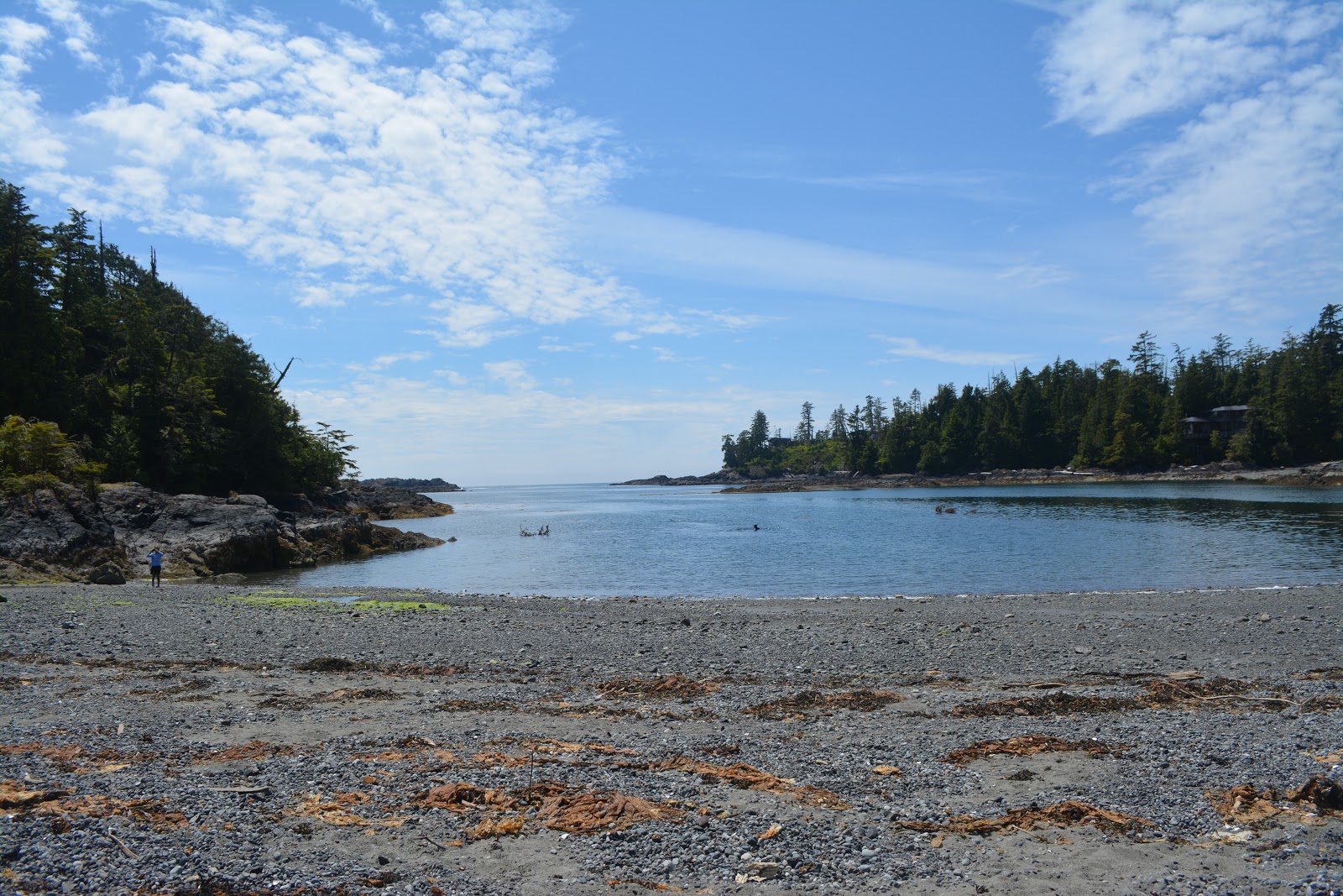
The first was China Beach on the southern shore of Vancouver Island. It's a relatively new park, and although it says it's on the beach, the beach is down a cliff about ¾ mile away.  It's not the ¾ mile, it's the cliff – all 289 steps, plus lots of other uphill parts of the trail. But it was well worth it in the end.  There were several tide pools, which is what I love to see, and lots of driftwood on the beach.  The most fun part of this campground was a friend that I made!  Occasionally I run into other women traveling alone, and I met Jocelyn on the beach.  We talked for a while, then climbed back to the campground together (it's so much easier when someone else is doing it with you!).  The next day we both had plans to go to another beach (Botanical Beach) down the road in Port Renfrew, so we teamed up and went together.  More great tide pools, more trails from the top of cliffs, more steps, but great companionship.  
China Beach

Some of the 289 steps

Botanical Beach
The tide pools were full of baby crabs, mussels, and anemones – lots of anemones, including some really tiny ones! It was so much fun to go from pool to pool to see what might be there! 
 
Mussels, anemones, and baby crabs
That evening, we had a campfire together, with wine and s'mores – what more could you want?!! 
 
Jocelyn eating a s'more! 
From the south part of the island I came north and east to the Courtenay area, about half-way up. From there I was able to explore north, south, and east.  Campbell River is a town that was recommended, and it did not disappoint! On the way up, I passed a crowded spot on the sidewalk with some traffic congestion, and when I glanced over, I saw that it was a chainsaw carving competition.  Well, that is something not to be missed!  And it was great fun.  My favorite among all the fabulous carvings was one that a woman was working on of a wolf. As I looked at it, I could almost hear the wolf howling at the moon!  There were other wonderful carvings, including one that was the head of a woman on one side and the head of an eagle catching a fish on the other. It was quite amazing.  
 
Howling Wolf

Side one
Side 2


I also hiked to a pretty waterfall called Elk Falls.  At the end of the trail is a suspension bridge that goes to a viewing platform on the other side of the river.  I looked and looked at it, but in the end I chickened out and stayed on my side of the river!  Suspension bridges just freak me out!  I found a lunch place too, that had great clam chowder, at a time when I had been craving clam chowder for several days – what a find! 


Elk Falls

The next day was a little more restful – a trip to the farmers market for strawberries and tomatoes, some of the best strawberries I've ever eaten!  Then a short hike to Nymph Falls in a small town to the east. 
 
Very tasty strawberries
The campground I'm staying in is really pretty – my site is right on the ocean and I can watch tides in the Salish Sea, several nights ago a cruise ship went by at high tide and the water lapping up on the rocky shore actually woke me up.  When I realized that there was also a beautiful sunset, I got up and got dressed again so I could go out and take photos. One of the fun things about this campground is that there is an eagle nest in one of the trees behind me. I've learned to distinguish the eagles screech, and also learned to dislike the crows that harass the eagle and also steal my food and get into my garbage.  
 
Campground view

Sunset

Today is a day for housekeeping – laundry, car wash, shower, clean the camper – one of those days that you need every so often!  But it's a great laundromat, with an entertaining owner, and it's a good place to write a blog.  Till next time……

Friday, June 14, 2019

Olympic National Park

Note:  I've spent way too much time trying to get the layout of this blog just right, and I can't do it.  So I hope you can relate the photos to the text --  sorry.....

For nine years I lived in the Pacific Northwest, only a 3 hour drive from this park, but this is the first time I've been here. I decided to give it the full treatment, spending a whole week here. I had a list of things I wanted to be sure not to miss, and I've been going through them pretty systematically. 

These guys were fishing on the way to my first stop
The first on the list was Cape Flattery – the northwestern most point in the lower 48 states. It's been on my bucket list and, oh my, it did not disappoint! Getting there is a challenge – it's a short trail, only about ½ mile or so, but it's full of tree roots, rocks, and very big steps. Not recommended for someone with weak knees (mine are metal, and not the strongest!). The trail is on Native American land and local residents have thoughtfully made available a supply of walking sticks (very nicely decorated, although I forgot to take a photo).  For this trip, I purchased a pair of trekking poles, and I was SO glad I had them. The trip to the end of the trail is mostly downhill, which means that coming back is uphill.  Tough – when you want something bad enough, you make it happen!  The return trip is supposed to take 20-25 minutes.  I made it back in one hour!  But I made it!  The ocean here is incredibly blue, and the day was clear and sunny.  I couldn't have asked for anything better! 


Further down the coast are some National Park beaches, some beautifully smooth sand with lots of families having fun, and a few with rocky stacks partway out in the water. This was my goal; the best tide pooling is around the base of these stacks at low tide. I had printed out tide tables at home before I left, so I knew when to go.  Again, I wasn't disappointed – lots of starfish and anemones at the base of the largest stack, and some other interesting formations around other stacks. Unfortunately, the best critter viewing was on the other side of a very large, deep puddle.  Thus my dilemma, do I go barefoot and end up with shoes full of sand, or just wade on through in my shoes (and jeans, water almost up to my knees!).  I chose the latter, but wish I had chosen the former. It's now more than 24 hours later and my shoes are still wet through.  I'm down to hiking boots or sneakers without heels (I don't know what they are called, but I wear them all summer). 


The stacks
Critters, lots of them! 

The stacks up closer


The Hoh rain forest is a very famous part of the park, and I spent some time there in the morning, including a hike through the Hall of the Mosses. The trees are heavily draped with moss, making them look very old and kind of spooky.  The moss is not a parasite – it feeds on the air and rain (and there is a lot of rain here!).  But the walk was beautiful in it's own way. There is a stream running through it and one of the photos below shows how clear the water is.  It's a picture of what looks like sticks and grass, and the water is about a foot deep. 

Taken through about 12" of water


Moss in the trees. 

A tree fell across the trail.  It's really huge!!


Today I'm on the Strait of Juan de Fuca side of the park, Hurricane Ridge. I got another stamp in my National Parks Passport (that's 4 for this trip!), yesterday I did a short hike around the meadow at the visitor center, then went into town and got a shower at the Y (a badly needed one!!)  A good day indeed! 
Wildlife on Hurricane Ridge

View from the visitor center at Hurricane Ridge. 


Wednesday, June 5, 2019

Beautiful Campgrounds

I'm now on my fourth great adventure in six years, and tonight I'm in one of the most beautiful campgrounds I've ever camped in. I'm at Salmon le Sac in the Wenatchee National Forest, and tonight I will fall asleep to the sound of the creek rushing about 15 feet from my van. 


There seem to be one or two of these campgrounds on every big trip; near Glenallen, Alaska, it was the Tonsina campground. Sinks Canyon in Lander, Wyoming was very snowy but also had a creek running nearby and the snow made for a magical sight. In Newfoundland, the campground at Dildo Run was right on the beach and I could watch the tide coming in and going out. 

This campground has no wifi or cell service, so by the time I get to post this blog, I'll be in Seattle. But I'll never forget campsite #39 at Salmon le Sac! 

On the Road Again

On the Road Again     

I play that Willie Nelson song on the first day (and on many other days) of any long trip, and often sing along at the top of my voice.  If my windows were open, I would probably scare other drivers!  But it sure is fun to be on the road again, with a very distant destination in mind.  I'm off to Alaska again!

Last week I spent some time near Houston for my grandson's high school graduation, and another grandson's confirmation.  IN between the two events, I spent a few days camping on Galveston Island.  That wasn't the plan, but Brazos Bend State park, famous for it's alligators, was closed because of flooding. So Galveston it was. I did find a few alligators, but most of them were very shy and sank below the surface of the water as I approached (in the car).  This one stayed put long enough for me to get a photo. I also caught up with an old high school friend that I hadn't seen in many years – that was a lot of fun.  
Alligator

The park on Galveston island is also home to a lot of birds, many of which I had seen before, but this Scissortail flycatcher was new to me.  He has an amazing long tail. 
Scissortail Flycatcher
After a few days at home, I started out for Alaska, with a few stops along the way. First up was Canyonlands National Park.  I'd been to Arches before (it's just down the road from Canyonlands) but this was my first time here.  It's quite beautiful in its own way, not as many rock formations, but much wider vistas. I even managed a short hike to Mesa Arch that was described as easy and mostly flat at the Visitor Center, but their flat and my flat are very different.  It seems they think about 150 feet elevation gain is nothing, but then they don't have COPD and hike with an oxygen concentrator.  I'm proud to say that I made it, although for a while I had my doubts.  I even have a photo to prove it!

The thing that surprised me most was that the landscape was grassy instead of desert. I'm not sure if it had recently rained a lot, or if this was its normal appearance. 

I did spend a couple of hours at Arches just to remind myself what it was like.  I also wanted to get my National Parks Passport stamped!  My Seattle grandkids gave it to me two years ago when we were camping at Glacier, and I have been getting it stamped wherever I can. It's fun to look back at the stamps and remember those places. 


Balanced Rock at Arches

Arches
Beautiful formation at Arches
Before I left Utah, there was one  more thing I wanted to see – Dead Horse Point.  It is an overlook of a horseshoe bend in the Colorado River and I'd seen many photos of it, but that's just no substitute for the real thing. So at 7 AM the next morning, I was at the lookout taking the obligatory photos. But really, it was much more; trying to imagine the history of that place was very sad.  Back in time, horses were brought there and left, and because there was no water, they died, thus the name. I'm not sure what the reasoning was, I just know it was a beautiful place with a very sad history.